The Spanish Acequias Of San Antonio
Couldn't load pickup availability
About this book
The Spanish Acequias Of San Antonio by I. Waynne Cox. hardcover edition. ISBN: 9781893271340.
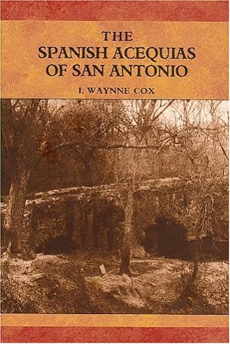
This is the first book on the remarkable 50-mile Spanish-era acequia system that supplied water to early San Antonio. It is believed to have been the most extensive such network within the present-day United States. One of the acequias, serving lands near Mission Espada, remains in use. Its 1730s stone aqueduct is a significant tourist attraction. New towns throughout the semiarid Spanish southwest depended for water on medieval systems designed by Spanish engineers using techniques brought to Spain from North Africa by the Moors. Their acequias, or irrigation ditches, used a variety of ingenious techniques such as hollowed logs, diversion dams and stone aqueducts to coax water from nearby streams to homes and fields. San Antonios founding was due to the presence of two major sources of water, San Pedro Springs and the headwaters of the San Antonio River. From these was developed perhaps the most extensive acequia system within the present-day United States. The network leading from six acequias originally served both the civilian community and five Spanish missions. Their often erratic courses determined property lines and the winding paths of many present-day streets. Longtime archeologist Waynne Cox, who uncovered many forgotten remains of the system, outlines acequia technology as well as the construction, evolution and, in most cases, the closing by the early twentieth century of San Antonios acequias. His pioneering account draws from a wealth of new information unearthed in the citys earliest municipal records. The books 23 illustrations include 8 maps, plus notes, a bibliography and an index.